MIOCENE STUDY | WHY STUDIES | SPECIFICATIONS | SAMPLES
Southwest Louisiana Lower Miocene
Scope
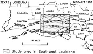
This multiclient proprietary study provides a comprehensive predictive model for sandstone in the Lower Miocene, Siph. davisi – Planulina trend of Southwestern Louisiana. The study completely integrates detailed well log correlation, micropaleontology, seismic interpretation and production data. It provides robust stratigraphic and depositional models, as well as specific locations and predictions of sand.
Click HERE to download a PDF (440K) base map.
Geologic Setting
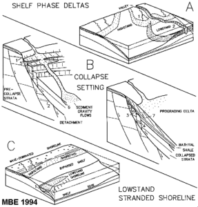
The Lower Miocene Siphonina davisi – Planulina zone of South Louisiana is a hydrocarbon-prolific, sand-rich zone that is up to several thousand feet thick. Producing reservoirs have undergone a complex history of deposition, diagenesis, migration, and multiple phases of structural activity. Sandstone reservoirs vary widely in geometry and orientation. Major geological features include: 1) salt domes, 2) salt withdrawal basins and minibasins, 3) arcuate growth fault systems, 4) shelf-edge slump-failure systems and 5) stacked detachments.
Integrating a Diverse Data Set
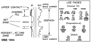
This study relies heavily on three principle data types: electric logs, micropaleontology and seismic. Electric logs were used to establish a detailed correlation framework based on depositional systems and modern stratigraphic principles in which processes rather than nomenclature is emphasized. Each of the log stratigraphic units in the prospective intervals is mapped individually for properties of the upper bounding surface of the unit, interval isopach, net sandstone, blocky sandstone, percent sandstone and log facies. Integrating with micropaleontology provides greater control on age, paleoenvironment and existence of anomalous section. Seismic data from Geophysical Pursuit Inc. was used to constrain bedding geometries and stratal architecture. We created a set of closely spaced stratigraphic cross sections that show the distribution of all features significant to prospecting in the trend. All of the above products incorporate production data.
Reconstructing Depositional Systems
We then integrated these cross sections, maps and other data to produce a paleogeographic map showing 1) depositional environments, 2) sandstone feeder systems to downdip areas, 3) contemporaneously active faults, 4) submarine canyons, 5) shelf-edge slumps, 6) salt features affecting depositional patterns, and 7) contemporaneous large-scale physiographic features such as the shelf edge and the slope.
Models for Predicting Downdip Sandstone
Understanding the stratigraphic and structural relationships enables the recognition of the important controls on sedimentation, which ultimately determine sandstone distribution. These processes include sediment transport mechanisms, depositional environments, submarine erosion, paleobathymetry, growth faulting, eustasy and salt movement. An appreciation of the processes, and how they interact with one another provides the basis for establishing a complex Lower Miocene depositional model that is far more powerful than conventional systems tracts designations. The resulting products enhance recognition of exploration targets in any portion of the study area, and in any of the depositional components of the Lower Miocene interval. Additional figures are shown in the Publication (Gulf of Mexico – 1994) section of this site.