YEGUA STUDY | WHY STUDIES | SPECIFICATIONS | SAMPLES
Middle Texas Yegua and SE Texas – SW Louisiana Yegua
Scope
The two multiclient proprietary studies provide a comprehensive predictive model for sandstone in the updip, middip and downdip areas of the Yegua/Cook Mountain trend of Texas and Louisiana. Both studies are completely integrated products that rely on detailed well log correlation, micropaleontology and seismic interpretation. They provide robust stratigraphic and depositional models, as well as specific locations and predictions of sand.
Click HERE to view a PDF (483K) base map of the Middle Texas Study.
Click HERE to view a PDF (418K) base map of the Southeast Texas – Southwest Louisiana Study.
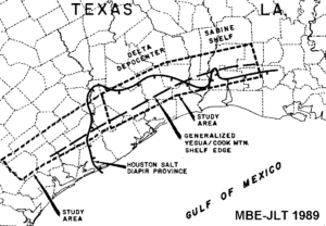
Geologic Setting
During mid to late Eocene time along the northern Gulf Coast Basin, a large Yegua – Cook Mountain delta complex prograded southwards. The depocenter approximately coincided with the Houston Salt Diapir Embayment in Southeast Texas. Along strike, the delta flanks extended to the San Marcos Arch in Texas, and to the central part of South Louisiana. The Middle Texas Study covers the western delta flank of the Liberty Delta System, while the SE Texas – SW Louisiana Study covers the depocenter and the eastern flank of the delta system.
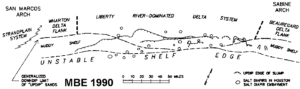
Integrating a Diverse Data Set
Both studies rely heavily on three principle data types: electric logs, micropaleontology and seismic. Electric logs were used to establish a detailed correlation framework based on depositional systems and modern stratigraphic principles in which processes rather than nomenclature is emphasized. Each of the log stratigraphic units in the prospective intervals is mapped individually for interval isopach, net sandstone, blocky sandstone, percent sandstone and log facies. Integrating with micropaleontology provides greater control on age, paleoenvironment and existence of anomalous section. Seismic data from both TGS Geophysical Onshore and proprietary sources were used to constrain bedding geometries and stratal architecture. We assembled a set of closely spaced stratigraphic cross sections that show the distribution of all features significant to prospecting in the trend. All of the above products incorporate production data.
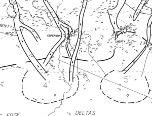
Reconstructing Depositional Systems
We then integrated these cross sections, maps and other data to produce a paleogeographic map showing depositional environments, sandstone feeder systems to downdip area, contemporaneously active faults, submarine canyons, shelf-edge slumps, salt features affecting depositional patterns, and contemporaneous large-scale physiographic features such as the shelf edge and the slope.
Models for Predicting Downdip Sandstone
Understanding of the stratigraphic and structural relationships enables the recognition of the important controls on sedimentation, which ultimately determine sandstone distribution. These processes include sediment transport mechanisms, depositional environments, submarine erosion, paleobathymetry, growth faulting, eustasy and salt movement. An appreciation of the processes, and how they interact with one another provides the basis for establishing a complex Yegua depositional model that is far more powerful than conventional systems tracts designations. The resulting products enhance recognition of exploration targets in any portion of the study area, and in any of the depositional components of the Yegua – Cook Mountain interval. Additional figures are shown in the Publications (Gulf of Mexico – 1990, 1991) section of this site.
Geologic Setting
During mid to late Eocene time along the northern Gulf Coast Basin, a large Yegua – Cook Mountain delta complex prograded southwards. The depocenter approximately coincided with the Houston Salt Diapir Embayment in Southeast Texas. Along strike, the delta flanks extended to the San Marcos Arch in Texas, and to the central part of South Louisiana. The Middle Texas Study covers the western delta flank of the Liberty Delta System, while the SE Texas – SW Louisiana Study covers the depocenter and the eastern flank of the delta system.
Integrating a Diverse Data Set
Both studies rely heavily on three principle data types: electric logs, micropaleontology and seismic. Electric logs were used to establish a detailed correlation framework based on depositional systems and modern stratigraphic principles in which processes rather than nomenclature is emphasized. Each of the log stratigraphic units in the prospective intervals is mapped individually for interval isopach, net sandstone, blocky sandstone, percent sandstone and log facies. Integrating with micropaleontology provides greater control on age, paleoenvironment and existence of anomalous section. Seismic data from both TGS Geophysical Onshore and proprietary sources were used to constrain bedding geometries and stratal architecture. We assembled a set of closely spaced stratigraphic cross sections that show the distribution of all features significant to prospecting in the trend. All of the above products incorporate production data.
Reconstructing Depositional Systems
We then integrated these cross sections, maps and other data to produce a paleogeographic map showing depositional environments, sandstone feeder systems to downdip area, contemporaneously active faults, submarine canyons, shelf-edge slumps, salt features affecting depositional patterns, and contemporaneous large-scale physiographic features such as the shelf edge and the slope.