This page contains publications that emphasize the Gulf of Mexico. Most major articles are accompanied by the abstract and a few key figures.
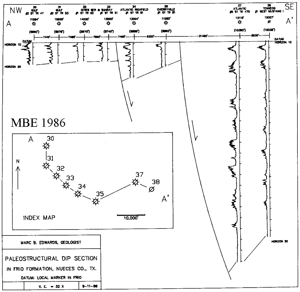
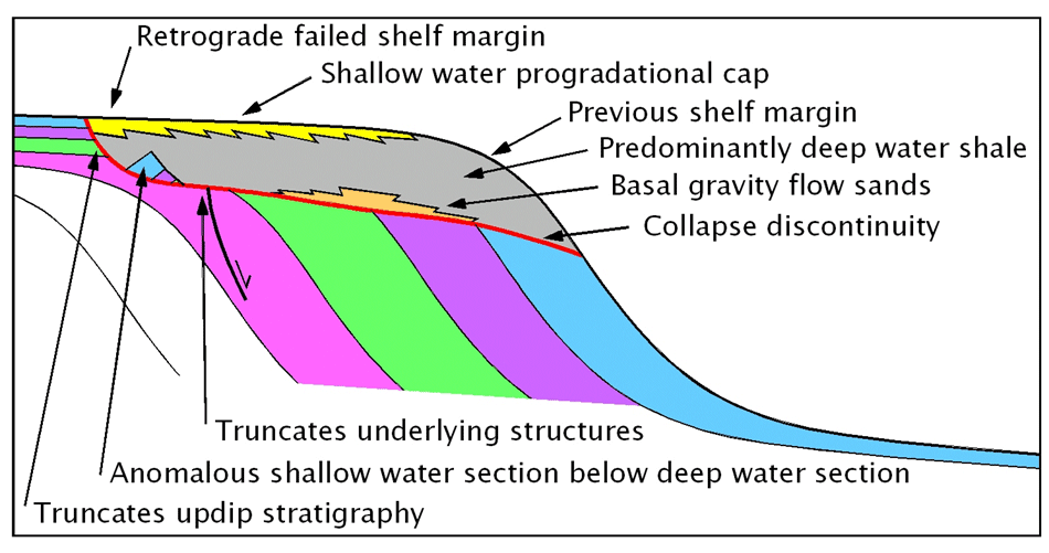
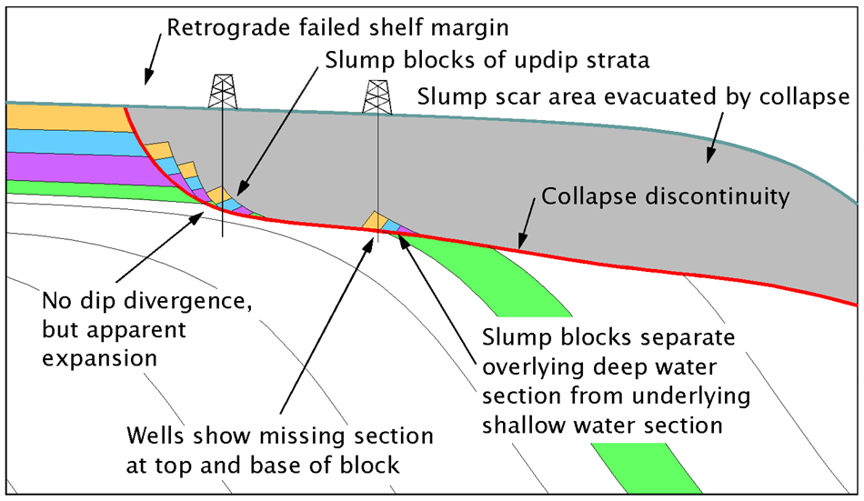
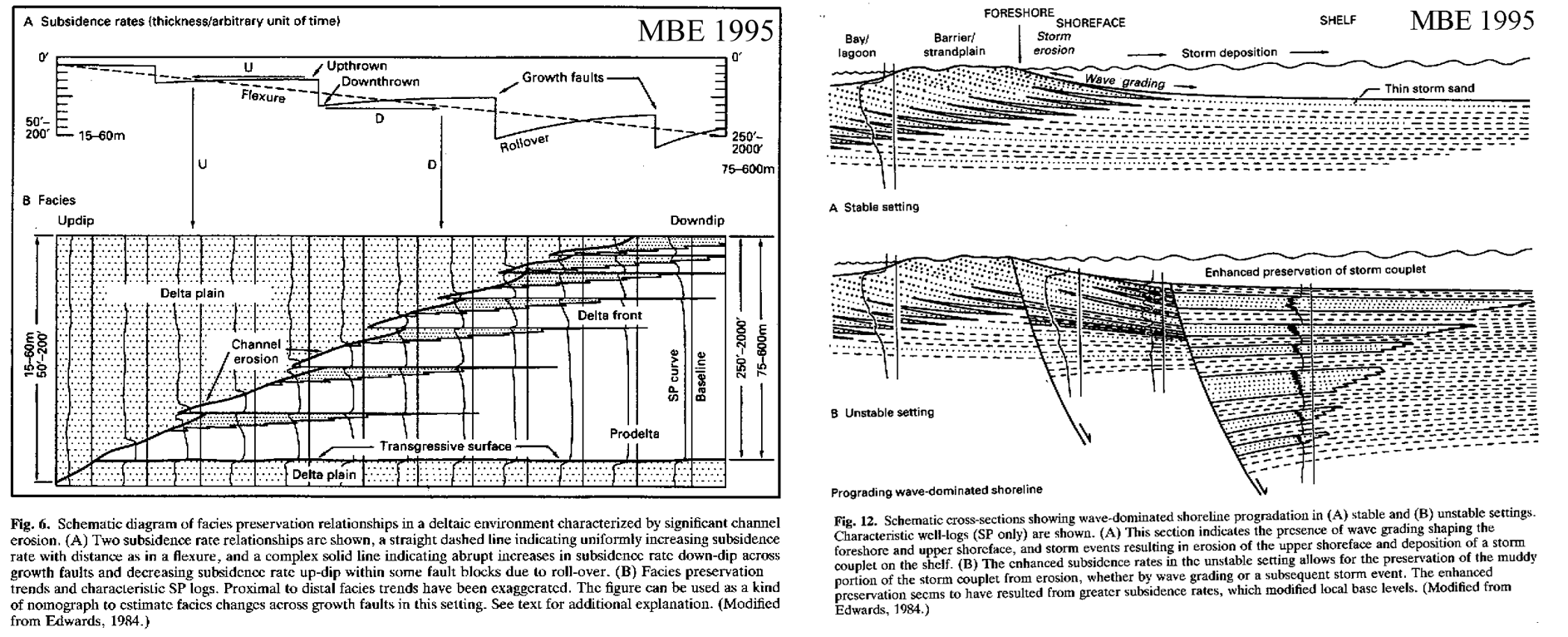
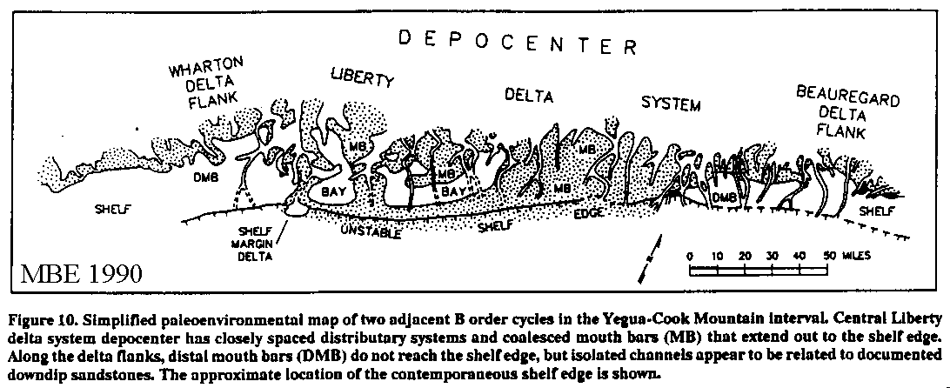
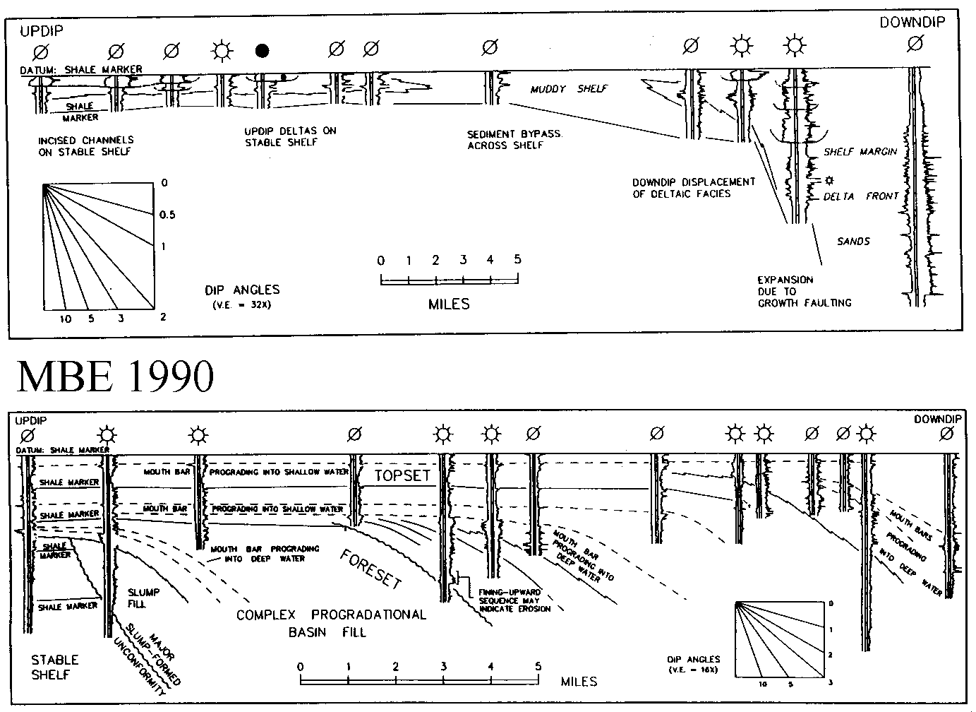
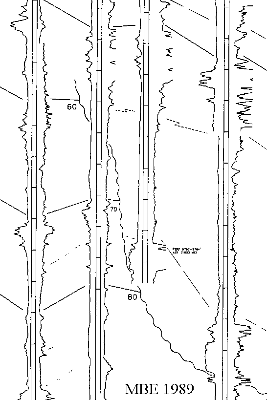
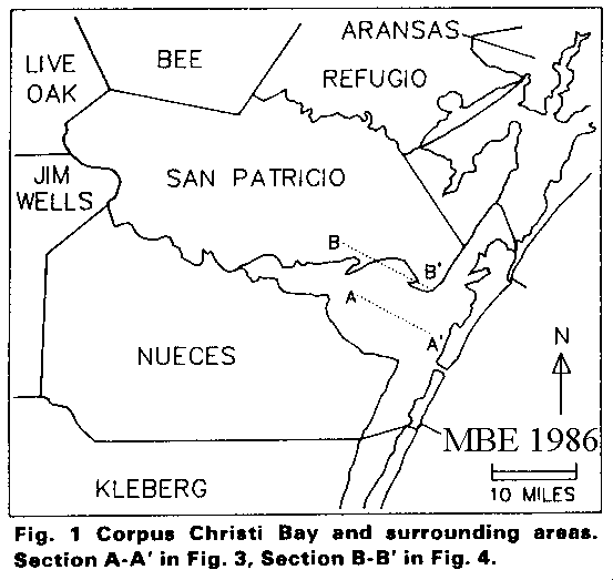
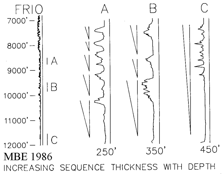
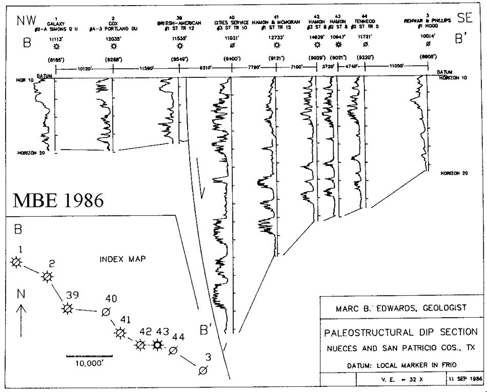
An in-depth discussion of the May, 2005 AAPG article by Brown et al. on the growth-faulted Frio of South Texas Summary: This is a discussion of a multi-author “sequence stratigraphic” study of growth-faulted Frio Formation of South Texas. This discussion is even more interesting because of the reply. If you take the time to read this stuff in detail, let me know what you think. CLOSE ALL The case for the regressive systems tract GCAGS 2002 The full paper is available online at the SEARCH AND DISCOVERY web site. ABSTRACT Until the advent of sequence stratigraphy (late 1980’s), geologists commonly subdivided the silici-clastic units of the Gulf Coast Basin into regressive and transgressive components. Sequence stratigraphy divided the regressive component into two separate units: the highstand systems tract (HST) and the lowstand systems tract (LST). In the years following the introduction of sequence stratigraphy (early 1990’s), it was noted in several publications that in areas where sediment input was active during a period of overall sea level fall, a single widespread sequence boundary did not form. Since the model necessitated the existence of a sequence boundary, stratigraphers argued over where the sequence boundary should be placed. To try to deal with this problem, the concept of “forced regression” was introduced, but this did not resolve the fundamental problems. Uncritical application of the original (eustatically forced) sequence-stratigraphic paradigm requires geoscientists to identify stratigraphic components without any basis in fact or theory. Where analysis of the data indicates that updip and downdip facies are genetically related, a sequence model may be inappropriate or misleading. In these cases, the term regressive systems tract is preferred, as it removes the need to identify a conceptual artifact: the chronostratigraphically and geometrically significant sequence boundary. CLOSE ALL Origin and significance of retrograde failed shelf margins Gulf Coast Basin GCAGS 2000 This article was awarded a Grover E. Murray best published paper award at the 2001 GCAGS Convention The full article is available at the SEARCH AND DISCOVERY web site. ABSTRACT The unusually high rates of sedimentation and subsidence in the Gulf Coast Basin are occasionally overwhelmed by large catastrophic collapse of the shelf margin that relocates the shelf margin landward behind the headwall of a strike-parallel slump scar. Unique reservoir and trapping opportunities are created by these genetically related processes: instantaneous (relatively speaking) creation of the collapse, emplacement of slump blocks into the collapse, possible uplift of the collapse scar headwall due to isostatic rebound, and transport of sediment gravity flows into and across the collapse scar. A review of the distribution of documented retrograde failed shelf margins suggests that many more remain to be discovered in the subsurface of the Gulf Coast Basin. It is recommended that careful geological modeling be combined with a regional perspective and 3-D seismic in order to discover new exploration opportunities in this hyper-mature basin. CLOSE ALL Differential subsidence and preservation potential of shallow water Tertiary sequences IAS 1995 Click here to download a PDF reprint of this article (1 mb) Made available with permission from Blackwell Publishing Ltd. ABSTRACT Growth faulting, which accompanied shelf-edge progradation and filling of the northern Gulf Coast Basin, resulted in partitioning of the basin margin into fault blocks with contrasting subsidence rates. Study of correlative sections in juxtaposed fault blocks reveals that contrasting subsidence rates can result in strongly differing facies patterns in neighbouring areas. This complicates the task of predicting sandstone reservoir occurrence and properties. Shallow-water clastic sections from Eocene to Miocene in age were investigated using extensive well-log observations, supplemented with micropalaeontology and seismic profiles. All depositional environments involve an ongoing, complex interplay between sedimentation and erosion at different time and physical scales. In certain settings, a greater subsidence rate causes the preservation of certain facies that would otherwise have been eroded at lower subsidence rates by processes inherent to the environment. The critical subsidence rate that separates preservation from non-preservation is termed the preservation potential threshold for a particular depositional facies. Examples are provided for progradational mouth-bar facies in a deltaic setting (Wilcox), and storm-deposited shoreface-shelf muds in a prograding shoreline setting (Frio). Where rates of subsidence are even greater, the growth fault may produce a topographical scarp at the surface, which will influence the disposition of depositional environments. Here, the concept of preservation thresholds is not adequate to account for the observed facies changes. Rather, the presence of the surficial scarp as the surface manifestation of the subsurface fault causes the preferential development and preservation of channel activity in the topographic lows, and progradational environments with channel bypass in the topographical highs. An example is provided for a series of prograding stacked deltas (Miocene). These concepts may help to focus attention on the role of subsidence in constraining the appearance of the sedimentary record. CLOSE ALL Enhancing sandstone reservoir prediction by mapping erosion surfaces, Lower Miocene Deltas GCAGS 1994 Abstract Three kinds of erosion surfaces were recognized in lower Miocene (Siphonina davisi-Planulina) deltaic depocenters near the paleoshelf margin in the southwest Louisiana Gulf Coast Basin. Understanding their characteristics and origin is important to both field development and exploration in the area. Each surface shares some characteristics of sequence boundaries. The first type of erosion surface is prominent updip and is associated with nonmarine to inner neritic microfaunas. The channel-like forms have a relief typically of 50 to 200 ft, may truncate older flooding and erosion surfaces, and exhibit a variety of patterns in map view, including radial and rectilinear. Sandstone-rich channelized deposits range from distributary channels on prograding deltas to incised valleys on subaerially exposed marine shelves. The two end members have contrasting implications for reservoir prediction and fill styles, but many examples are intermediate types that do not fall in one end member type or the other where laterally adjacent erosional features occur between two flooding surfaces, timing relationships were ambiguous. The third type of erosion surface occurs at the base of strike-oriented, isolated sandstone bodies in an otherwise shaly, outer shelf setting. Away from these sandstones, however, there is no evidence of erosion. Thus, this erosion surface formed in association with lowstand, stranded shoreline deposits. CLOSE ALL Control of depositional environments ... on sandstones, unstable shelf edge delta, Eocene Yegua GCAGS 1991 ABSTRACT Predicting the locations and geometry of downdip sandstone reservoirs in the Yegua trend of Texas and Louisiana is a key challenge to explorationists. In order to formulate and test depositional and stratigraphic models for this purpose, well log, seismic and biostratigraphic data were integrated over a distance of about 350 miles along strike. The resulting correlation framework, based on almost 4,500 well logs, extends from updip on the stable shelf to the downdip limit of well control on the slope. Well logs provide the highest stratigraphic resolution in this data set. On the stable shelf, the entire Yegua-Cook Mountain sand-bearing interval is about I,000-1,500 ft. thick. Shale markers which show tens to hundreds of miles of continuity along strike bracket progradational cycles 100-300 ft. thick. These log-defined cycles comprise the basic mapping units used in this study. Seismic reflectors in this zone are essentially parallel. Downdip of the shelf, complications were introduced by growth faulting, erosion due to slope failure, mass wasting of sediments overlying failure-induced erosion surfaces, and complex patterns of basin fill seaward of the shelf margin. This complex zone thickens basinward to several thousand feet. All of these zones were further complicated by contemporaneous and post-depositional salt movement in the Houston Salt Diapir Province. Biostratigraphic data were used to determine general ages for downdip section, to indicate prominent discontinuities, and to show environmental trends. Large-scale slope failures occurred several times during Yegua deposition, resulting in regional erosional unconformities. It is not known if their origin is related to eustacy. Slope deposits that onlap extensive erosional surfaces are also well represented, but their precise age relationship to updip systems is unclear. Paleoenvironments were interpreted from maps of log-derived interval isopach, net sand, percent sand, blocky sand and log facies. Each mapping unit is bounded by regionally correlatable shale zones interpreted to have formed during high stands. Strata bounded by the markers represent systems tracts comprising upper delta plain, lower delta plain, mouth bar, distal mouth bar, and shelf. Inferred local shelf bypassing, and channel incision and basinward shifts in facies suggest small but significant falls in sea level during deposition. Each of these cycles resemble “depositional sequences” but in terms of their duration they are described as high frequency fourth order events. Small-scale stratigraphic complexity within the mapped units suggests frequent autocyclic shifts of depocenters. Effective sand prediction downdip to the shelf edge and upper slope is accomplished using transgressive shale (“condensed section” or “flooding surface”) markers as a stratigraphic framework, while recognizing the significant effects of eustatic sea-level changes. Although widespread erosional unconformities, possibly equivalent to sequence boundaries, could be mapped on the slope, neither unconformities nor correlative conformities could be identified sufficiently on the shelf to enable their detailed and regional mapping. CLOSE ALL Stratigraphic analysis and reservoir prediction in Eocene Yegua and Cook Mountain of Texas and Louisiana GCS-SEPM 1990 ABSTRACT Predicting the locations and geometry of downdip sandstone reservoirs in the Yegua trend of Texas and Louisiana is a key challenge to explorationists. In order to formulate and test depositional and stratigraphic models for this purpose, well log, seismic and biostratigraphic data were integrated over a distance of about 350 miles along strike. The resulting correlation framework, based on almost 4,500 well logs, extends from updip on the stable shell to the downdip limit of well control on the slope. Well logs provide the highest stratigraphic resolution in this data set. On the stable shelf, the entire Yegua-Cook Mountain sand-bearing interval is about 1,000-1,500 ft thick. Shale markers which show tens to l00’s of miles of continuity along strike bracket progradational cycles 100-300′ thick. These log-defined cycles comprise the basic mapping units used in this study. Seismic reflectors in this zone are essentially parallel. Downdip of the shelf, complications were introduced by growth faulting, erosion due to slope failure, mass wasting of sediments overlying failure-induced erosion surfaces, and complex patterns of basin fill seaward of the shelf margin. This complex zone thickens basinward to several thousand feet. Biostratigraphic data were used to determine general ages for downdip section, to indicate prominent discontinuities, and to show environmental trends. Large-scale slope failures occurred several times during Yegua deposition, resulting in regional erosional unconformities. It is not known if their origin is related to eustacy. Slope deposits that onlap extensive erosional surfaces are also well represented, but their precise age relationship to updip systems is unclear. Effective sand prediction downdip to the shelf edge and upper slope is accomplished using transgressive shale (“condensed section” or “flooding surface”) markers as a stratigraphic framework, while recognizing the significant effects of eustatic sea-level changes. Although widespread erosional unconformities could be mapped on the slope, neither unconformities nor correlative conformities could be identified sufficiently to enable detailed and regional mapping on the shelf. CLOSE ALL Exploration significance of erosional unconformities in the Downdip Yegua Northern Gulf Coast Basin HGS 1989 TEXT Detailed log correlation, micropaleontological surveys, and regional seismic data have documented the presence of regionally extensive erosional unconformities in downdip areas of the Middle to Late Eocene Yegua – Cook Mountain Formations in the Texas and Louisiana Gulf Coast Basin. The erosion surfaces extend from Wharton County, middle Texas Gulf Coast, to Beauregard Parish in Louisiana, a distance of approximately 200 miles. The stratigraphic phenomena that are associated with these unconformities can readily be confused with other causes, such as post-depositional faults, growth faults, facies changes, pinchouts of various types, and progradational wedges. But the proper recognition of the erosion surfaces greatly increases the power of sand prediction in the middle and downdip parts of the trend. The erosion surfaces have highly variable geometries, ranging from strike-continuous surfaces that can be traced for many tens of miles along strike and which erode through as much as several thousand feet of older section, to narrow, arcuate surfaces that have a dip orientation and widths of 10 miles or less. In some cases, the surfaces truncate older erosional events within the Yegua – Cook Mountain section. Detailed log correlation has provided a high resolution framework for demonstrating that the erosion surfaces formed at many different times during Yegua – Cook Mountain deposition. The same degree of resolution does not appear to be available with existing micropaleontological or seismic data. An origin by catastrophic slump failure of the shelf edge seems necessitated by the strike-continuous nature of the most prominent erosion surfaces. It is possible that some of the linear dip-oriented examples were also scoured, at least in part, by bottom-hugging gravity flows. Timing of erosional episodes in relation to eustatic sea-level changes has not been demonstrable due to the higher frequency of erosional events compared to the frequencies of sea-level fluctuation events as identified in the literature (i.e. Hag et. al., 1988). The exploration significance of the these erosion surfaces is as follows: 1. Older strata are eroded away in downdip areas, so that downdip projections of sand within depositional Systems subsequently removed by erosion are invalid. 2. Scour of the erosion surfaces creates deep water (sub-wave base) conditions favorable for the action of gravity flow mechanisms. The resulting bathymetric basins generally form on the updip portion of the slope. The geometry of the bathymetric basins and the provision of sediment to the basin that was created by erosion will determine the potential for preservation of gravity flow deposits upon the erosion surface, or at other levels within the deep water basin fill. Some sandy gravity flow deposits may equivalent to the “basin floor fan” systems tract recognized in seismic facies analysis (Posamentier and Vail (1988). Such deposits may occur as a stratigraphic trap that pinches out against the unconformity and is sealed by shales both below and above. 3. The abrupt change from shallow to deep water conditions caused by the erosional events, results in a change in depositional geometries from horizontal aggradational strata updip (below the erosion surface) to clinoform progradational strata downdip (above the erosion surface). subsequent erosional events will cut into inclined strata, and therefore be more difficult to recognize. The resulting complex depositional-erosional slope deposits may harbor many types of sand bodies with a good potential for stratigraphic trapping but poor potential for sand body prediction. 4. The unconformity may act as a structural decollment surface for the overlying strata. Shallow structural events may hence not project into deeper strata. The accompanying dip-oriented cross section front the Texas downdip Yegua trend in Liberty county illustrates stacked regressive sequences updip truncated by a basinward inclined erosion surface of approximately lower Yegua age. Above the erosion surface are blocky sands that formed as gravity flow deposits. Note the production from the updip, shallow well. The sand is overlain by a thick shaly section that probably shows a clinoform geometry on seismic data. The accompanying window from a regional seismic dip line from the middle Texas downdip Yegua has been segmented and separated to illustrate some of the geologic events that occurred in this area. Dashed lines show the presence of inferred major unconformities. The upper of these surfaces formed during Yegua – Cook Mountain sedimentation. The truncation of horizontal strata can be seen updip to the left, while the filling of the bathymetric basin created by erosion can be seen above the erosion surface to the right. References Edwards, M.B. and Tuttle, J.L., 1985, Sandstones of the Downdip Yegua, Middle Texas Gulf Coast Basin. Proprietary Study (unpublished). Edwards, M.B. and Tuttle, J.L., 1987, Downdip Yegua Trend, Southeast Texas Southwest Louisiana. Proprietary Study (unpublished). Haq, B., Hardenbol, J. and Vail, P.R., 1988, Mesozoic and Cenozoic chronostratigraphy and cycles of sea-level change. In: Sea-level Changes: an Integrated Approach, SEPM Spec Pub; No. 42, p. 77-108. Posamentier, H.W. and Vail, P.R., 1988, Eustatic controls on clastic deposition II – sequence and systems tract models. In: Sea-level Changes: an Integrated Approach, SEPM Spec Pub; No. 42, p. 77-108. Acknowledgments I appreciate the support of the oil and gas companies that funded the proprietary studies from which the above information is extracted. J. Loyd Tuttle and Paleo Control Inc. carried the micropaleontological studies that resulted in the recognition and/or corroboration of some or the erosion surfaces. A large number of Regional seismic lines was made available by TGS Onshore Geophysical Company, which also provided the seismic data shown in the accompanying figure. CLOSE ALL Sedimentary effects of differential subsidence in Frio shoreface-shelf sediments, Gulf Coast Tertiary HGS 1986 ABSTRACT Sedimentologists and stratigraphers commonly invoke mechanisms such as changes in sea-level, subsidence rates and sediment supply to explain transgressive and regressive trends. In most cases, however, it is impossible to independently validate such interpretations. An important exception is the growth-faulted sedimentary sequences of the Gulf Coast Basin which were deposited at varying subsidence rates in closely juxtaposed locations. This short article presents some observations form the Oligocene Frio Formation of South Texas and suggests that subsidence rate is an independent parameter that influences reservoir character and geometry, and corresponding log and production characteristics. Approximately 600 well were correlated, and a series of detailed structural and stratigraphic cross-sections were compiled. Interpretations of stratigraphy and environment were based on study of electric log character. INTRODUCTION In general, the major growth-faulted zones of the Gulf Coast Basin correspond to the position of the contemporary shelf-edge (Winker and Edwards, 1983). Structurally. the shelf-edge is an extensional zone caused by the downslope creep of the muddy sediments on the continental slope. The extension results in rotated fault blocks, in which the strata often dip counter to the regional dip Despite the overall thinning which results from the extension, thereby enhancing subsidence rates, the strongly regressive character of these shelf-edge sequences indicates that sediment supply greatly overwhelmed subsidence. This would also have inhibited the development of substantial bathymetric relief. The considerable local variations in subsidence rate, both within and between adjacent fault blocks, resulted in corresponding variations in the thickness of sediments deposited during individual regressive sequences, These thickness variations are readily determined using paleostructural interval isopach mapping (Edwards, 1980). DEPOSITIONAL MODEL During Frio time, the study area (Figure 1) was the site of a wave-dominated shoreline, as suggested by both the strikewise continuity of stratigraphic units and the updip pinchout of all sandstones into marginal marine muddy sediments (Martin, 1969). A typical log through the entire Frio Formation (Figure 2) shows the gradual upward change from marine shales to shoreline sandstones, Several segments of the log (SP only is shown) are presented to show how sedimentary sequences (shown by the V’s) become thinner upwards in the well. If it is assumed that regressive depositional cyclicity was caused by a process that had a roughly uniform occurrence through time, then it follows that the changes in thickness reflect changes in subsidence rates Thus, the lower part of the Frio was subjected to high subsidence rates consistent with the structural instability of the shelf-edge. As the regression proceeded, subsidence rates decreased with increasing structural stability. Detailed stratigraphic sections illustrate another aspect in the relationship between contrasting thickness and log character of sequences. Section A-A’ (Figure 3), datum below the regional “J” in local nomenclature. shows expansion across two major contemporaneous faults with modest rollover, whereas section B-B (Figure 4), datum below regional. At the other extreme, out on the shelf, wave action is low in local nomenclature emphasizes the effects of dramatic rollover expansion- Figure 3 emphasizes that in addition to thickening, increased subsidence results in a change in log character from digitate sand units updip to ratty serrated sand units downdip. This is present also in the stratigraphically lower unit shown in Figure 4. A core study (Berg and Powell, 1976) through the serrated sand facies from a nearby well illustrated the turbidite-like character of the sands. The main problem is to explain the downdip change from blocky barrier-bar sands updip into an intermediate digitate facies and finally into a shelfal serrated sand facies downdip. In general terms, this can be accomplished with the standard regressive shoreface model (Mccubbin, 1982) which is diagrammatically shown in the upper panel of Figure 6. Progradation of the upper shoreface, a wave-dominated environment, and its associated inlet channels results in the updip facies (Galloway, 1986). Wave agitation retains finer sediment in suspension. Eventually, it is deposited in quieter water on the lower shoreface and shelf. While storms accomplish much damage and erosion of upper shore-face sediments, repair and renewed progradation occur almost immediately due to the frequency and efficacy of waves in this zone and infrequent, Sands are emplaced by high energy bottom flows that result from major storms. The exact nature of these flows, whether gravity driven, current driven or a combination, is still debated. In any event deposition of sediment during the waning of the flow gives rise to a turbidite-like deposit The alternation of sand deposition during storms, with mud deposition from both the waning storm flow and suspension during intervening quiet periods, gives rise to the interbedded serrated log character of this facies. These contrasting forces, low energy high frequency waves and high energy low frequency storms, compete in the lower shoreface. Small-scale fluctuations in the local sediment supply in combination with the transition from the upper to the lower shoreface probably give rise to the intermediate digitate sand facies. Here, sands are part wave-deposited (mostly in the form of lenses in silt and mud deposited from suspension) and part storm-deposited (erosively-based sand beds). However, immediately adjacent. on the downthrown side of a large growth fault (Figure 5, lower panel), the digitate sands are somehow transformed into serrated sands, As there was no abrupt change in environment, the cause appears to be variations in subsidence rate In the lower shoreface, high subsidence rates in wave-influenced areas ensure that fine-grained deposits are preserved, by burial, from erosion by wave reworking. Similarly, high subsidence rates in storm-influenced areas ensure that the fine-grained end-of-storm-flow deposits and suspension deposits are preserved from erosion by large storm events. Following from these speculations is the concept of a preservation potential threshold. Deposits that result from a particular sedimentary environment in which competing erosional and depositional forces contrast in energy level and frequency, mayor may not reflect varying subsidence rates. It is only when the subsidence rate changes beyond a certain value or threshold, that the resulting deposit is influenced. While it is apparent that this 5 applicable to areas such as the Gulf Coast Basin where there are large changes in subsidence rate over short spans of distance and time, it must also be pertinent to the interpretation of environment in basins that had varying subsidence rates though a diverse tectonic history. Inversely, it seems likely that sediment supply has an analogous effect The same environment can result in totally contrasting sedimentary sequences depending on the sediment supply rate. CONCLUSION As basin analysis becomes more powerful and quantitative, perhaps these lines of reasoning may provide a route for further understanding and research. MeanwhiIe, in the Gulf Coast, “What’s happening on the other side of the fault?” is still an important and valid question, whose answer should never be taken for granted. Other settings characterized by differing sets of sedimentary processes, such as river-dominated deltas, and gravity-influenced delta front slopes will illustrate their own unique subsidence-rate relationships to sedimentary and log attributes. REFERENCES CITED Berg R. R. and Powell, R R., 1976, Density-flow origin for Frio reservoir sandstones Nine Mile Point Field, Aransas County, Texas. Trans Gulf Coast Assoc. Geol. Socs v.26, p. 310-319 Edwards, M. B.,1980, The Live Oak delta complex: an unstable shelf-edge delta in the deep Wilcox trend of South Texas: Trans. Gull Coast Assoc. Geol. Socs. V 30, p.71-79. Edwards, M. B., unpublished, Stratigraphic and Structural Analysis of Growth-Faulted Regions Using Well Logs – A Workshop. Course Notes. Galloway, W E., 1986, Reservoir facies architecture of microtidal barrier Systems. AAPG Bull. v.70. p.787-808 Martin, C. B., 1969, The subsurface Fr?o of South Texas stratigraphy and depositional environments as related to the occurrence of hydrocarbons: Trans. Gulf Coast Assoc Geol Socs v.19, p 489-499. Mccubbin, D. G.. 1982, Barrier-Island and Strand-Plain Facies: in Sandstone Depositional Environments, AAPG Mem. 31. p.247-279. Weise, B H. et al., 1981, Geologic studies of geopressured and hydropressured zones in Texas: Test-well site selection. Final report prepared by the Texas Bureau of Economic Geology for the Gas Research Institute under contract number 5011-321-0125. Winker, C 0. and Edwards, M. B., 1983, Unstable progradational clastic shelf margins: SEPM Spec PubI. No 33, p. 139-157. ACKNOWLEDGMENTS This paper, is based on an original study (Weise. et al. 1981) that examined the stratigraphy and structure of the Frio Formation in selected areas of the Texas Gulf Coast. That study was funded by the Gas Research Institute in order to locate reservoirs suitable for unconventional energy production. I acknowledge helpful discussions with Bonnie Weise and assistance from Don Downey, Susan Hallam, Steve Mann, and Doug Wilson. CLOSE ALL Depositional environment, Lower Wilcox sandstones of Valentine Field, Lavaca County, Texas Gulf Coast STGS 1986 ABSTRACT Two detailed studies of lower Wilcox sandstone reservoirs of the Valentine and Menking Fields arrived at contrasting conclusions as to the depositional environment of the sandstones. The purpose of this paper is to explain the reason for this conflict and to resolve the observations into a coherent model. Chuber (1979) regarded the sandstones to have been deposited in barrier bar and related coastal environments, while Berg (1979) favored turbidite deposition in an outer shelf to slope setting. The reason for the divergence of opinions is apparently a miscorrelation of the key Harkins No.1 Paul well log. A new interpretation of this log places the main unconformity below the turbidite sandstones observed in cores from this well. Thus, the turbidite sandstones occur within an erosional channel and are separated from the thick sandstone unit that comprises the main reservoir. This modification is consistent with Chuber’s barrier bar model for the main reservoir sandstones, and also supports Berg’s deeper-water interpretation for the overlying non-reservoir sandstones which fill the lower part of a submarine canyon. CLOSE ALL Unstable progradational clastic shelf margins SEPM 1983 Click here to download a PDF reprint of this article (1.6 mb) Made available with permission from SEPM (Society for Sedimentary Geology, copyright holder) In some continental margin basins such as the northwestern Gulf of Mexico and the Niger Delta, large-scale slumping of the continental slope disturbs the topset-foreset geometry of the prograding shelf margin and thereby inhibits recognition of ancient shelfedges. As a result, concepts of shelf-margin dynamics have been underemphasized in explaining the structure and stratigraphy of such basins. Nonetheless, ancient unstable clastic shelf margins can be approximately located by criteria such as isopach maxima, timing of growth faulting, and the stratigraphic top of geopressure. Gravity sliding of the continental slope creates a strongly extensional regime along the shelf margin, resulting in growth faulting and greatly enhanced subsidence rates. The corresponding compressional regime along the lower slope is important in initiating salt and shale structures; if the shelf margin progrades over these structures, diapiric activity can greatly complicate the style of growth faulting. High subsidence rates result in greatly expanded progradational cycles, which serve to distinguish shelf-margin deltaic sequences from deltas of the more stable shelf platform. Rapid fault movement along the shelf margin can hydraulically isolate shallow-water sandstones and juxtapose them against dewatering slope shales, thus allowing the development and maintenance of excess fluid pressure. These deep-water shales are probably a major source of both hydrocarbons and brines instrumental in diagenesis of geopressured deltaic sandstones. CLOSE ALL Wilcox Sandstone Reservoirs in the Deep Subsurface along the Texas Gulf Coast BEG 1982 ABSTRACT Regional studies of the lower Eocene Wilcox Group in Texas were conducted to assess the potential for producing heat energy and solution methane from geopressured fluids in the deep-subsurface growth-faulted zone. However, in addition to assembling the necessary data for the geopressured geothermal project, funded by the U.S. Department of Energy, this study has provided regional information of significance to exploration for other resources such as lignite, uranium, oil, and gas. Because the focus of this study was on the geopressured section, emphasis was placed on correlating and mapping those sandstones and shales occurring deeper than about 10,000 ft. The Wilcox and Midway Groups comprise the oldest thick sandstone/shale sequence of the Tertiary of the Gulf Coast. The Wilcox crops out in a band 10 to 20 mi. wide located 100 to 200 mi. inland from the present-day coastline. The Wilcox sandstones and shales in the outcrop and updip shallow subsurface were deposited primarily in fluvial environments; downdip in the deep subsurface, on the other hand, the Wilcox sediments were deposited in large deltaic systems, some of which were reworked into barrier-bar and strandplain systems. Growth faults developed within the deltaic systems, where they prograded basinward beyond the older, stable Lower Cretaceous shelf margin onto the less stable basinal muds. Continued displacement along these faults during burial resulted in (1) entrapment of pore fluids within isolated sandstone and shale sequences and (2) buildup of pore pressure greater than hydrostatic pressure and development of geopressure. Regional electric log correlation markers made possible the subdivision of the Wilcox into lower, middle, and upper parts. The net-sandstone map of the lower Wilcox indicates a dominantly lobate pattern northeast from De Witt County to the Sabine River. Fisher and McGowen (1967) interpreted the lower Wilcox in that area to have been deposited in a high-constructive delta system, which they named the Rockdale Delta System. To the south, the lower Wilcox net-sandstone map indicates a narrow, elongate trend; Fisher and McGowen interpreted these sediments to have been deposited in strandplain and barrier-bar systems and named them the San Marcos Strandplain and Cotulla Barrier-Bar Systems. The dominantly shale section of the middle Wilcox was deposited as a result of a marine transgression over the lower Wilcox. Thus, the shale is an offshore equivalent both of middle Wilcox sandstones far up dip and of sandstones of the lower part of the upper Wilcox. Information on subsurface pressures and pressure gradients was obtained from (1) bottom-hole shut-in pressure data from drill-stem tests, (2) shale resistivity data from electric logs, (3) mud weights from well log headings, and (4) shale transit times from sonic logs. The top of geopressure was picked at approximately the depth where a pressure gradient of 0.7 psi per foot occurs. This depth is considered the “operational” top of geopressure because it is somewhat higher pressure than the 0.465 psi per foot hydrostatic pressure gradient. The zone where pressure gradients are between 0.465 and 0.7 psi per foot is transitional and difficult to identify consistently. The resulting map indicates that the top of geopressure occurs between depths of 8,000 and 13,000 ft along the Wilcox trend; in general, the top of geopressure is deeper in high-sandstone areas and shallower in high-shale areas. Formation temperatures, corrected to equilibrium values, were determined throughout the Wilcox trend to permit calculation of the amount of methane dissolved in the water. Knowledge of subsurface temperature is also essential in studying diagenesis of sandstone, dewatering of shale, and maturation of organic material and generation of hydrocarbons. As a result of this regional study of the Wilcox Group, six geothermal fairways were identified-Zapata, Duval, Live Oak, De Witt, Colorado, and Harris. Thick sandstone units with formation temperatures greater than 300 degrees F occur in all fairways; however, high porosity and permeability occur in only the DeWitt Fairway (Cuero area), making it the only one having high potential for geopressured geothermal energy production. CLOSE ALL Upper Wilcox Rosita delta system of South Texas: growth-faulted shelf-edge delta AAPG 1981 This article was awarded the Sproule Memorial Award by the American Association of Petroleum Geologists in 1983. ABSTRACT The Rosita delta system, a heretofore unrecognized, major depositional system preserved in the deep upper Wilcox of south Texas, was delineated by detailed correlation of approximately 500 well logs. The Rosita delta system comprises at least three delta complexes, each of which can be traced up to tens of miles along strike and up to approximately 15 mi (24 km) downdip. Basinward, across the growth-fault zone, each delta complex thickens from about 600 ft (180 m) to more than 3,000 ft (900 m). The growth faults were activated by progradation of deltas over unstable prodelta-slope muds at the contemporary shelf margin. The three upper Wilcox delta complexes studied in detail are, from oldest to youngest, the Duval, Zapata, and Live Oak deltas, named for the counties in which they are centered. Each complex consists of several lobes, some of which can be traced across the deep zones where the thickness increases by as much as tenfold owing to progradation over active growth faults. Characteristic coarsening-upward progradational units are interpreted from electric log patterns to include prodelta shales, delta-front sandstones, distributary channel and channel-mouth bar sandstones, and interdistributary shales and sandstones. Appreciable variability in sandstone distribution in the deltas may reflect changing importance of fluvial versus marine currents in distributing sediment along the delta front. However, all of the deltas prograded abruptly toward the shelf margin. The gulfward extent of these delta complexes is unknown, and it is concluded that appreciable quantities of sandstone remain to be explored in the deep subsurface of the trend. CLOSE ALL The Upper Wilcox Rosita delta system of South Texas CCGS 1980 INTRODUCTION This study of the upper Wilcox of South Texas was conducted to locate sandstone reservoirs suitable for the production of geopressured geothermal energy. Such reservoirs ideally have high permeabilities of at least 20 md and should be capable of producing 40,000 barrels per day of hot, pressured methane-saturated water (Bebout et al., 1978). The potential reservoirs outlined by this study, and for which permeability data were available, have permeabilities that are too low for sufficiently high rates of water production. This investigation is based largely on the detailed correlation of approximately 500 well logs and a commercially available structure map on the top of the Wilcox. A depositional framework of Wilcox Group was first proposed by Fisher and McGowen (1967) and Fisher (1969). These authors considered the important Wilcox sandstone reservoirs stretching between Zapata and Bee Counties to represent lower Wilcox shelf edge sands reworked along strike from the Rockdale Delta System located to the northeast. In the present study, the major sandstones of the South Texas deep Wilcox trend have been interpreted as belonging to the upper Wilcox, and to having been deposited in large growth-faulted delta complexes that prograded out to the shelf edge. These conclusions conflict with previous studies which have suggested that 1) the upper Wilcox formed in high-destructive deltas which did not undergo extensive growth faulting (Fisher, 1969), and 2) the deep upper Wilcox was deposited in deep water by turbidity currents (Berg and Tedford, 1977) CLOSE ALL The Live Oak delta complex, an unstable shelf-edge delta in the deep Wilcox trend of South Texas GCAGS 1980 ABSTRACT Detailed correlation and study of approximately 500 well logs from the deep Wilcox trend of south Texas have shown the presence of at least three major deltaic complexes in the Rosita delta system. These sandstone-bearing units, previously considered to be a lower Wilcox strike-transported, shelf-edge sand facies, are reinterpreted as upper Wilcox deltas that prograded across a stable shelf to an unstabled shelf margin. The Live Oak Delta complex, the youngest observed, comprises numerous lobes. The youngest of these, the Luling and Slick deltas, are both extensively growth faulted and show a downdip change from delta plain to prodelta facies. Areas of maximum net sandstone occur in the downdip part of the growth fault zone where rapid relative subsidence rates compensated for basinward decrease in sandstone percent. A Gulfward displacement of facies and associated growth faults occurred between deposition of the older Luling to deposition of the younger Slick delta. This suggests that the deltas prograded out to the shelf margin and that the associated growth faults reflect gravity instability related to the adjacent prodelta slope. CLOSE ALL Prospect areas for testing entrained methane resources (Wilcox) ..., Texas Gulf Coast GCGGEC 1980 ABSTRACT Delineation of the four zones on regional cross sections and a survey of sandstone distribution defined sandstone-rich corridors for each of the zones. Net-sandstone maps defined high~sandstone fairways within the corridors. These fairways were ranked on the basis of net-sandstone thickness, areal sandstone distribution, average sandstone bed thickness, permeability, and coincidence with fairways of other zones. The most prospective fairways within the Frio Formation are Cameron, Kenedy, Corpus Christi, and Matagorda; the Montgomery Fairway is within the Wilcox Group. One or two prospect areas within each fairway are being studied in detail. Several sites for wells which will test the various pressure zones will be selected within the prospect areas. CLOSE ALL Wilcox Group--potential for geopressured-geothermal energy GCGGEC 1980 ABSTRACT The objective of this study is to identify areas along the Wilcox trend favorable for producing large quantities of hot water from the geopressured zone in order to separate methane from solution and produce electrical energy from heat. Reservoirs likely to contain geopressured geothermal fluids in economic quantities occur in the Wilcox Group where the gulfward-dipping sandstone/shale wedge thickens abruptly across a complex growth-fault system. The Wilcox comprises sandstone-rich upper and lower parts representing two major progradational cycles, and a shale-rich middle part representing a major transgression. Lower Wilcox deltaic sequences occur in lobate patterns along the Middle and Upper Texas Gulf Basin, while major upper Wilcox deltas occurring the Lower Texas Gulf Basin. On the basis of maximum sandstone development and formation temperatures greater than 300 degrees F (1490C), six geothermal fairways were delineated in Zapata, Duval, Live Oak, De Witt, Colorado, and Harris Counties. In addition, detailed studies were conducted to identify sites for drilling test wells. The De Witt Fairway is considered the prime test site area; the Cuero Prospect contains more than 550 ft (170 m) of sandstone with an area of approximately 14 mi (36 km2). The prospective sandstones occur at the tops of at least eight coarsening upward cycles; progressively shallower cycles contain increasingly permeable sandstones deposited in more proximal deltaic environments. The Colorado Fairway contains the second test site area. The Eagle Lake Prospect contains 1,240 ft (380 m) of sandstone and extends over an area of approximately 10 mi2 (26 km2). However, there is a question as to the presence of adequate thickness of high-permeability zones. CLOSE ALLEdwards, 2006: Understanding growth-faulted, intraslope subbasins by applying sequence-stratigraphic principles: Examples from the south Texas Oligocene Frio Formation: Discussion, AAPG Bull v. 90, 5, 787-798.
Edwards 2002 : The Case for the Regressive Systems Tract With Examples From the Tertiary and Pleistocene of the Northern Gulf Coast Basin. Trans. Gulf Coast Assoc. Geol. Socs. v. 52, 243-255.
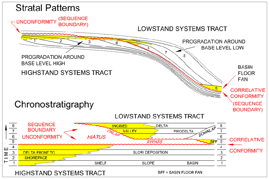
According to sequence stratigraphic theory, the HST and theLST are separated by a sequence boundary, with two implications: (1) the LST of a particular sequence is younger than the HST of the preceding sequence, and (2) the two systems tracts contains facies that are not genetically related.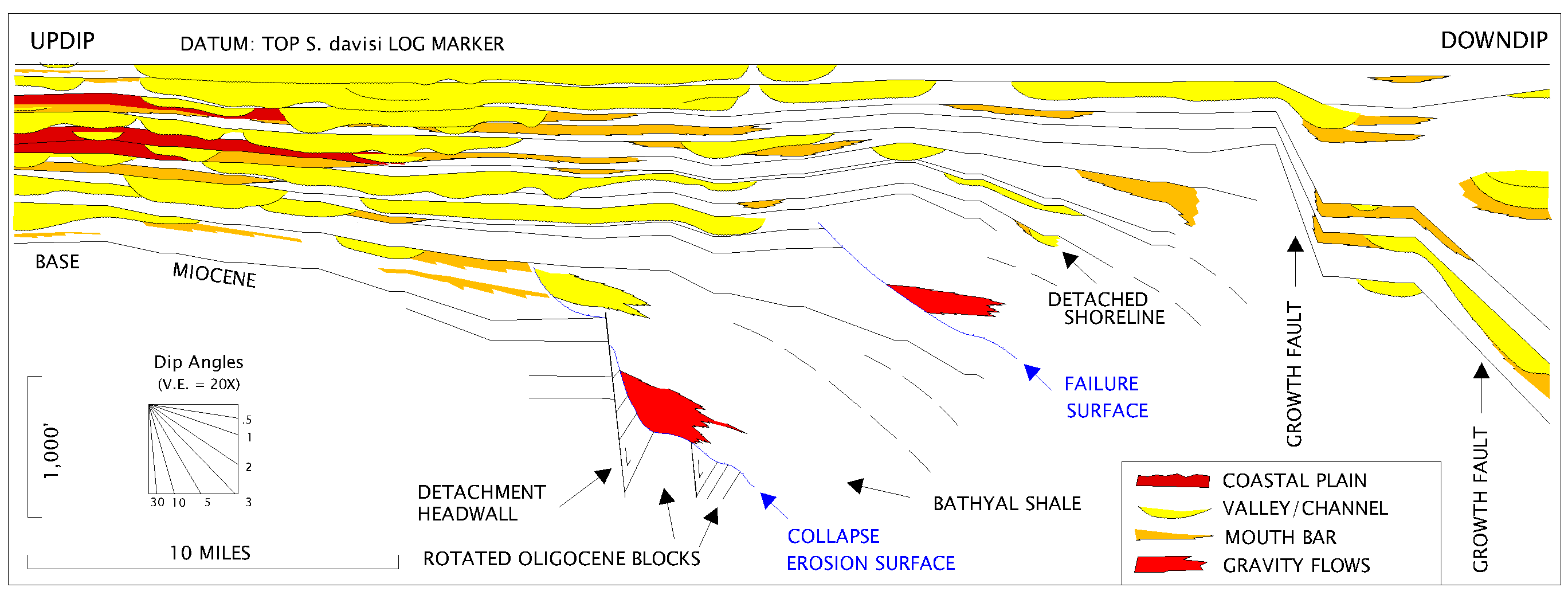
Edwards 2000: Origin and significance of retrograde failed shelf margins; Tertiary northern Gulf Coast Basin. Trans. Gulf Coast Assoc. Geol. Socs. v. 50, p. 81-93.
Edwards 1995: Differential subsidence and preservation potential of shallow water Tertiary sequences, Northern Gulf Coast Basin, U.S.A. In: Sedimentary Facies Analysis: A Tribute to the Research and Teaching of Harold G. Reading. Int’l. Assoc. Sed. Spec. Publ. 22, p. 265-281.
Edwards 1994: Enhancing sandstone reservoir prediction by mapping erosion surfaces, Lower Miocene Deltas. Southwest Louisiana, Gulf Coast Basin. Trans. Gulf Coast Assoc. Geol. Socs. v. 44, p. 205-215.
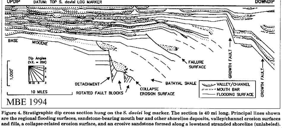
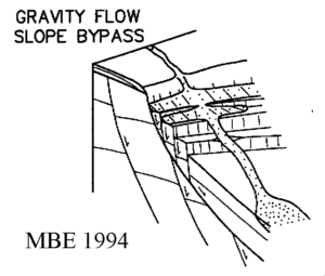
The second type of erosion surface is associated with outer neritic to bathyal microfaunas. These surfaces are broadly strike oriented, are regionally extensive, and have much higher relief than the channel features. They truncate rotated blocks of section containing older flooding and erosion surfaces and are overlain by local sediment gravity flow sandstones and a wedge of bathyal shale (Abbeville facies). These erosion surfaces formed subaqueously by shelf-margin collapse. They are much less common than channelized erosion surfaces, and no genetic relationship between the two is evident.Edwards 1991: Control of depositional environments, eustasy, and gravity and salt tectonics on sandstone distribution in an unstable shelf edge delta, Eocene Yegua Formation, Texas and Louisiana Trans. Gulf Coast Assoc. Geol. Socs. v. 41, p. 237-252.

Edwards 1990: Stratigraphic analysis and reservoir prediction in the Eocene Yegua and Cook Mountain Formations of Texas and Louisiana. In: Sequence Stratigraphy as an Exploration Tool, Gulf Coast Section SEPM, 11th Annual Res. Conf. p. 151-164.
 Paleoenvironments were interpreted from maps of log-derived interval isopach, net sand, percent sand, blocky sand and log fades. Each mapping unit is bounded by regionally correlatable shale zones interpreted to have formed during high stands. Strata bounded by the markers represent systems tracts comprising upper delta plain, lower delta plain, mouth bar, distal mouth bar, and shelf. Inferred local shelf bypassing, and channel incision and basinward shifts in facies suggest small but significant falls in sea level during deposition. Each of these cycles resemble “depositional sequences” but in terms of their duration they are described as high frequency fourth order events. Small-scale stratigraphic complexity within the mapped units suggests frequent autocyclic shifts of depocenters.
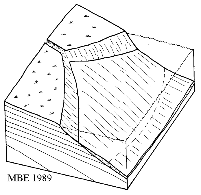
Edwards and Tuttle J.L., 1989: Exploration significance of erosional unconformities in the Middle to Late Eocene Downdip Yegua Northern Gulf Coast Basin: The Downdip Yegua – State of the Trend, Houston Geol. Soc.
Edwards 1986: Sedimentary effects of differential subsidence in Frio shoreface-shelf sediments, Gulf Coast Tertiary. Houston Geol. Soc. Bull. 29, 3, 10-14.
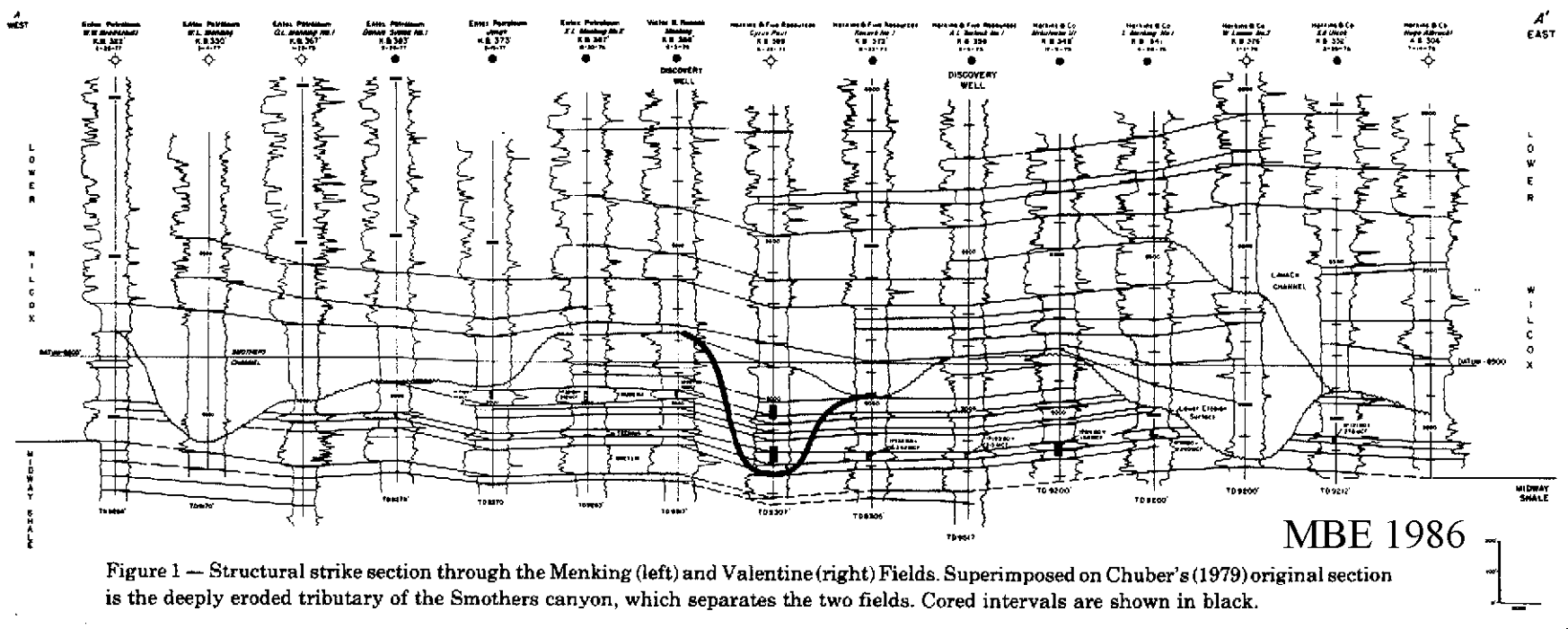
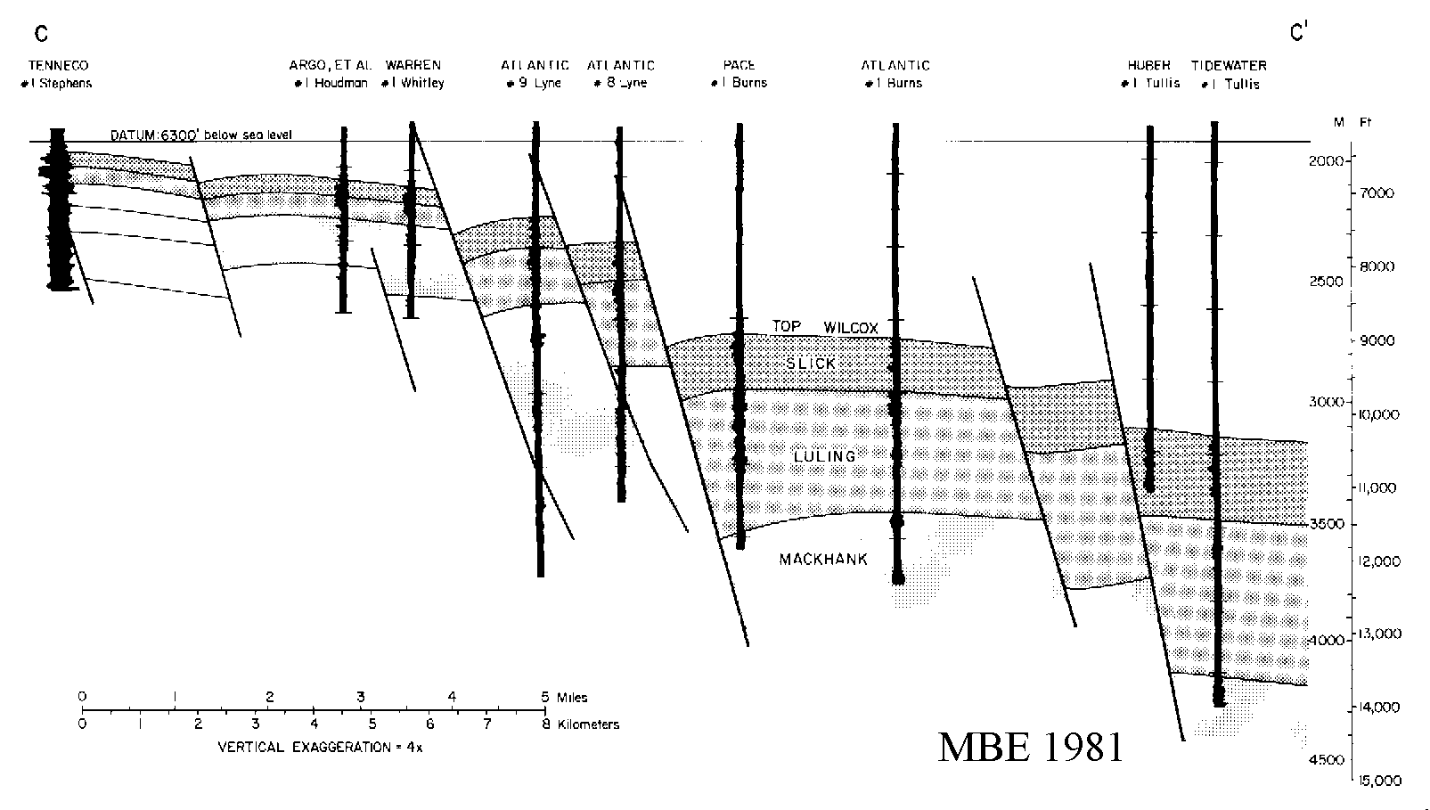
PRESERVATION POTENTIAL THRESHOLD Edwards 1986: A reappraisal of depositional environment (barrier bar or submarine fan) for Lower Wilcox sandstones of Valentine Field, Lavaca County, Texas Gulf Coast. South Texas Geol.Soc.; Contributions to the Geology of South Texas. 252-259.
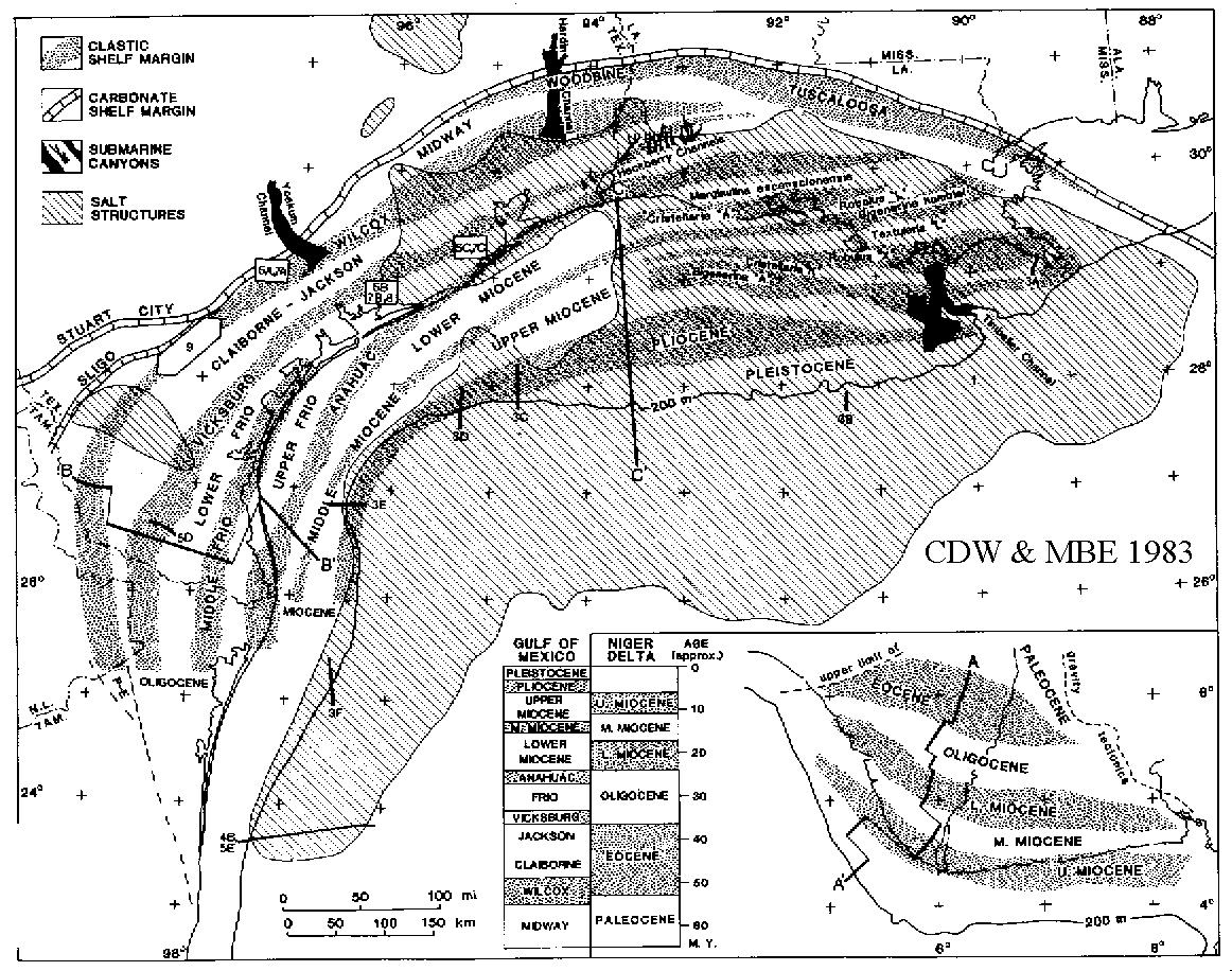
Winker, C.D. and Edwards 1983: Unstable progradational clastic shelf margins. In: Soc, Econ. Pal. Min. Spec. Publ. 33: The Shelf Break: Critical Interface on Continental Margins. (Eds D.J. Stanley & G. Moore.) 139-157.
ABSTRACT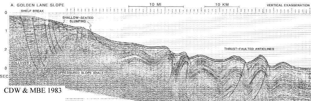
Bebout, D.G., Weise, B.R., Gregory, A.R. and Edwards 1982: Wilcox Sandstone Reservoirs in the Deep Subsurface along the Texas Gulf Coast, Their Potential for Production of Geopressured Geothermal Energy. Texas Bureau of Economic Geology Rept. Invest. 117, pp. 125.
The net-sandstone map of the upper Wilcox indicates abrupt thickening along the Lower and Middle Texas Gulf Coast, resulting from deposition contemporaneous with faulting in major deltaic systems. In contrast, along the Upper Texas Gulf Coast, abrupt downdip thickening does not occur, and these strata are not extensively growth faulted.Ewards 1981: Upper Wilcox Rosita delta system of South Texas: growth-faulted shelf-edge deltas. Amer. Assoc. Petrol. Geol. Bull. 65, 54-73.
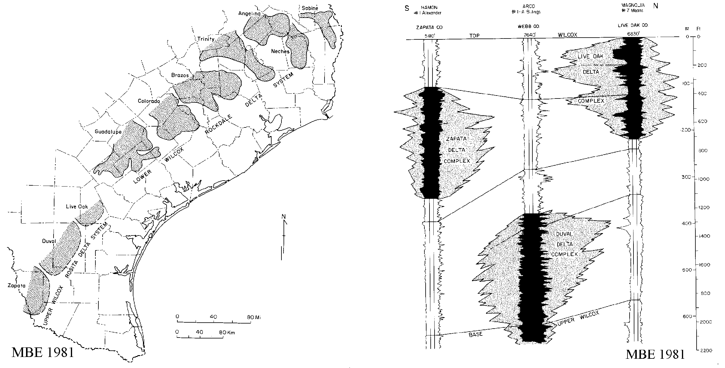
Edwards 1980: The Upper Wilcox Rosita delta system of South Texas. Corpus Christi Geol. Soc. Bull. February, 1980, 5-11.
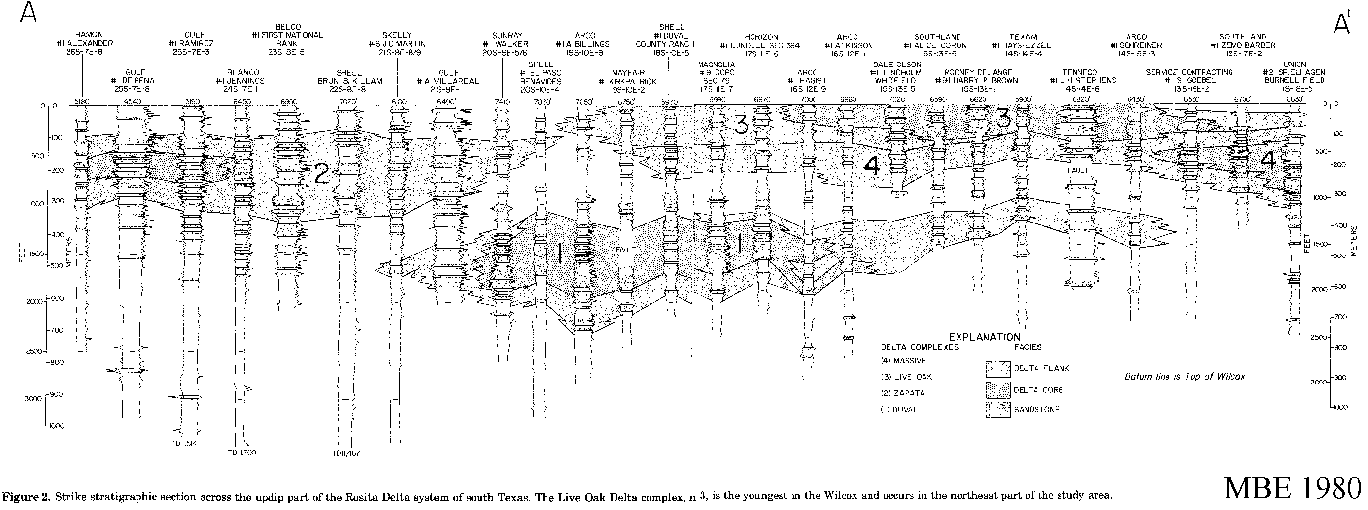
Edwards 1980: The Live Oak delta complex, an unstable shelf-edge delta in the deep Wilcox trend of South Texas. Gulf Coast Assoc. Geol. Socs. Trans. 30, 71-79.
Weise, B., Allie, A.S., Bebout, D.G., Edwards, Gregory, A.R., Hamlin, H.S. and Lockley, J.L. 1980: Prospect areas for testing entrained methane resources in the shallow geopressured and deep hydropressured zones, Texas Gulf Coast. in: Proc. 4th U.S. Gulf Coast Geopressured Geothermal Energy Conf.: Research and Development, Austin, 1979, (Eds. M.H. Dorfman & W.L. Fisher), 474-514.
The primary objective of geological studies of geopressured zones funded by the Gas Research Institute is to identify the most favorable sites for test wells which will be capable of long-term production of methane-bearing water from primarily the shallow geopressured and secondarily the deep hydropressured zones of the Texas Gulf Coast. To facilitate study, four zones within the hydropressured and geopressured Tertiary section were defined as follows: (1) the A zone, or deep hydropressured zone below depths of 4,500 ft (1,370 m), in which the fluid pressure gradient is 0.465 psi/ft (10.5 kpa/m), (2) the B zone, in which fluid pressure gradients are greater than 0.465 psi/ft (10.5 kpa/m) but less than 0.7 psi/ft (15.8 kpa/m), (3) the C Zone, in which fluid pressure gradients are greater than 0.7 psi/ft (15.8 kpa/m) and fluid temperatures are less than 300 degrees F (149 degrees C), and (4) the D Zone, in which fluid pressure gradients are greater than 0.7 psi/ft (15.8 kpa/m) and temperatures are greater than 300 degrees F (149 degrees C). This study concentrates on the A, B and C zones; the D zone has been the subject of previous studies of geopressured geothermal energy.Edwards, Bebout, D.G., Gregory, A.R., and Weise, B.R. 1980: Wilcox Group–potential for geopressured-geothermal energy. in: Proc. 4th U.S. Gulf Coast Geopressured Geothermal Energy Conf.: Research and Development, Austin. 1979, (Eds. M.H. Dorfman & W.L. Fisher), 312-371.